Dhaka, Oct 6 (Just News): Dhaka has reacted strongly and lodged an official protest against maps reportedly displayed on Myanmar government websites that show the St Martin’s Island as part of the country’s territory.
The government on Saturday summoned Myanmar Ambassador in Dhaka U Lwin Oo and strongly protested the matter.
Maritime Affairs Unit Secretary at the Ministry of Foreign Affairs Rear Admiral (retd) M Khurshed Alam summoned the Myanmar envoy to his office in the afternoon and handed over a strongly-worded protest note.
However, Myanmar Ambassador Lwin acknowledged the matter saying that it was a "mistake" to show the St Martin's Island as part of their own territory, according to a diplomat.
The island was never a part of Myanmar if anyone looks back at the history since 1937 and Dhaka says there is an 'ulterior motive' behind drawing and sharing the map of Myanmar on websites.
It was part of British-India when Myanmar got separated back in 1937, said an official adding that this means it was part of India. "A clear line was drawn in between."
In 1974, it was clearly stated through a signed agreement that the island is part of Bangladesh, said the official.
"Even when Bangladesh won the maritime boundary dispute against Myanmar through International Tribunal for the Law of the Sea in March 2017, it was clearly mentioned that the island is part of Bangladesh," the official said.
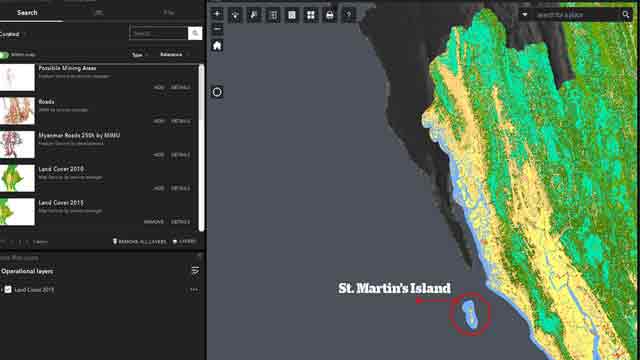
This screenshot was taken from the website of Myanmar Information Management Unit's (Mimu) website, which clearly shows the St Marin's Island (circled in red) included in the Myanmar territory
He went on saying: "There's no doubt. How could they (Myanmar) claim St Martin's Island as part of their territory? It's a deliberate attempt."
He reportedly asked the Myanmar envoy why the Myanmar side carried out survey in St Martin's Island. "You can't do it. On what basis you did it?" Khurshed Alam was quoted as telling the Myanmar envoy.
The Myanmar envoy was tight-lipped with a gloomy face when the UNB correspondent approached to know why he was summoned.
The maps were reportedly uploaded to two Myanmar government websites showing St Martin's Island as a part of Myanmar's territory.
The Myanmar envoy pledged to discuss the matter with his government and convey Dhaka's concerns.
The 2014 Population and Housing Census - Myanmar's first national census in 30 years - was undertaken by the Ministry of Immigration and Population with technical support from UNFPA between 30th March and 10th April 2014, according to Myanmar Information Management Unit.
Earlier, Myanmar circulated a picture that claims to show insurgents training, which is actually a photograph of freedom fighters during the Liberation War of Bangladesh in 1971.
The Myanmar military later issued a rare apology acknowledging that the photographs it published in a book on the crisis over the Rohingya community were ”published incorrectly."
(Justnews/ys/2310hr)


